Gravel-Tour nach Radweg Weißenbachtal R15
● Gravel boucleprès de Koppl, AT·partagé par @pedals_and_pretzels
99 km880 mBoucle3 points
99 km
Distance
880 m
Dénivelé
3
Points
Gravel
Revêtement
Avec VeloPin Pro, vos points arrivent avec les bonnes icônes et vos notes sur un Garmin, Wahoo, COROS ou Karoo, au lieu de simples points sans nom.
Télécharger seulement la trace (.gpx)À propos
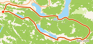
This gravel loop is 100 km and features 880 m of total climbing. Starting and ending around Koppl, AT, the route heads out toward Bad Ischl, AT, before returning to the start.
Profil altimétrique
↑ 880 m dénivelé total
Points 3

Trinkwasserstelle
Eau

Shell-Service-Station
Station-service
En bref
- TerrainVallonné — 880 m / 99 km
- TypeBoucle
- Idéal pourGravel
- Arrêts3 points
Types de revêtement
Bitume / Goudron 29% · 28,4 kmNon revêtu / Terre <1% · 1 kmGravier 18% · 17,7 kmInconnu 52% · 52 km