Tegernsee – Sylvensteinspeicher Runde von Tegernsee
● Strada anellovicino a Waakirchen, DE·condiviso da @pedals_and_pretzels
83 km578 mAnello3 waypoint
83 km
Distanza
578 m
Dislivello
3
Waypoint
Strada
Fondo
Con VeloPin Pro i tuoi waypoint arrivano con le icone e le note giuste su Garmin, Wahoo, COROS o Karoo, invece che come punti senza nome.
Scarica solo la traccia (.gpx)Info sul percorso
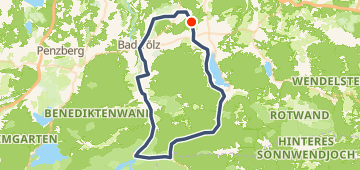
Diese 83 km lange Rundstrecke beginnt und endet in Waakirchen. Sie führt größtenteils flach durch die Landschaft und erreicht ihren weitesten Punkt in der Nähe von Lenggries. Insgesamt sind 578 m Höhenunterschied zu bewältigen.
Profilo altimetrico
↑ 578 m dislivello totale
Waypoint 3

Water fountain
Acqua

Sylvensteinspeicher
Panorama
In sintesi
- TerrenoOndulato — 578 m / 83 km
- TipoAnello
- Ideale perStrada
- Soste3 waypoint
Mix di fondo
Asfalto 97% · 80,4 kmSconosciuto 3% · 2,5 km