Munich's "Where's the Schnitterin?" Loop
● Gravel loopnear Munich, DE·shared by @pedals_and_pretzels
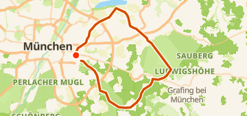
72 km338 mLoop6 waypoints
72 km
Distance
338 m
Elevation gain
6
Waypoints
Gravel
Surface
With VeloPin Pro your waypoints arrive with the right icons and your notes on a Garmin, Wahoo, COROS or Karoo, instead of as nameless dots.
Just download the route track (.gpx)About this route
Diese 72 km lange Gravel-Rundstrecke beginnt und endet in München. Mit insgesamt 338 m Steigung, größtenteils flach, führt sie in die Nähe des Eglhartinger Forsts und schließt sich dort zum Kreis.
Elevation profile
↑ 338 m total climb
Waypoints 6

Schnitterin-Brunnen
Water

Maibaum Schule
Attraction
At a glance
- TerrainMostly flat — 338 m / 72 km
- ShapeLoop
- Best forGravel
- Stops6 waypoints
Surface mix
Asphalt / Paved 30% · 21.6 kmUnpaved / Dirt 1% · 0.7 kmGravel 23% · 16.6 kmUnknown 46% · 33.2 km
More gravel routes near Munich, DE
91km and I'm still thirsty
gravel loop · 91 km · 600 m
MUC - Verona Tag 1
gravel point-to-point · 107 km · 1,184 m
2.5h gravel
gravel loop · 57 km · 198 m
130km Gravel_München - Ammersee
gravel loop · 128 km · 755 m
Gravel-Tour nach Karolinengeräumt (Forstenrieder Park)
gravel loop · 118 km · 850 m
Gravel-Tour nach Scenic Route from Sachsenkam to Kleinhartpenning via Kloster Reutberg
gravel loop · 109 km · 504 m