Tegernsee -> Schliersee Rodeo
● MTB loopnear Gmund, DE·shared by @pedals_and_pretzels
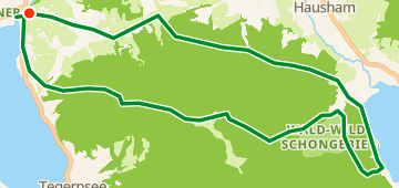
30 km1,249 mLoop3 waypoints
30 km
Distance
1,249 m
Elevation gain
3
Waypoints
MTB
Surface
With VeloPin Pro your waypoints arrive with the right icons and your notes on a Garmin, Wahoo, COROS or Karoo, instead of as nameless dots.
Just download the route track (.gpx)About this route
Diese Mountainbike-Rundstrecke startet und endet in Gmund. Mit 30 km und 1249 m Gesamtanstieg führt sie in Richtung Schliersee, bevor sie zum Ausgangspunkt zurückkehrt.
Elevation profile
↑ 1,249 m total climb
Waypoints 3

Water fountain
Water

Rezeption Gastronomie
Coffee
At a glance
- TerrainHilly — 1,249 m / 30 km
- ShapeLoop
- Best forMTB
- Stops3 waypoints
Surface mix
Asphalt / Paved 31% · 9.3 kmUnpaved / Dirt 11% · 3.3 kmGravel 46% · 13.8 kmUnknown 12% · 3.6 km