Von Fluss Prien nach Weiße Traun bei Ruhpolding
● Gravel loopnear Aschau im Chiemgau, DE·shared by @pedals_and_pretzels
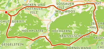
89 km1,458 mLoop5 waypoints
89 km
Distance
1,458 m
Elevation gain
5
Waypoints
Gravel
Surface
With VeloPin Pro your waypoints arrive with the right icons and your notes on a Garmin, Wahoo, COROS or Karoo, instead of as nameless dots.
Just download the route track (.gpx)About this route
This hilly gravel loop is 89 km long with 1458 m of total climbing. Starting and ending in Aschau im Chiemgau, DE, the route heads out toward Ruhpolding, DE, before returning to the start.
Elevation profile
↑ 1,458 m total climb
Waypoints 5

Near - Schöner Wasserfall
Viewpoint

Penny
Groceries
At a glance
- TerrainHilly — 1,458 m / 89 km
- ShapeLoop
- Best forGravel
- Stops5 waypoints
Surface mix
Asphalt / Paved 40% · 35.4 kmUnpaved / Dirt 6% · 5.3 kmGravel 50% · 44.3 kmUnknown 4% · 3.5 km