Gravel-Tour nach Dachstein Südwand — Day 2
● Gravel point-to-pointnear Ebensee, AT·shared by @pedals_and_pretzels
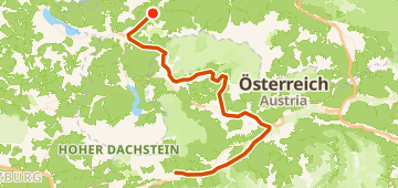
104 km1,356 mPoint-to-point7 waypoints
104 km
Distance
1,356 m
Elevation gain
7
Waypoints
Gravel
Surface
With VeloPin Pro your waypoints arrive with the right icons and your notes on a Garmin, Wahoo, COROS or Karoo, instead of as nameless dots.
Just download the route track (.gpx)About this route
This gravel point-to-point ride runs from Ebensee, AT to Haus im Ennstal, AT. The route covers 104 km with 1356 m of total climbing, featuring gently rolling terrain.
Elevation profile
↑ 1,356 m total climb
Waypoints 7

Radweg entlang des Rettenbachs
Waypoint

Water fountain
Water
At a glance
- TerrainRolling — 1,356 m / 104 km
- ShapePoint-to-point
- Best forGravel
- Stops7 waypoints
Surface mix
Asphalt / Paved 62% · 64.4 kmGravel 21% · 22.2 kmUnknown 17% · 17.9 km