Quast-Route ORIGINAL
● Gravel point-to-point·shared by @marius_quast1
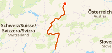
515 km6,772 mPoint-to-point102 waypoints
515 km
Distance
6,772 m
Elevation gain
102
Waypoints
Gravel
Surface
With VeloPin Pro your waypoints arrive with the right icons and your notes on a Garmin, Wahoo, COROS or Karoo, instead of as nameless dots.
Just download the route track (.gpx)About this route
Das Abenteuer, wie es im Film gefahren wurde. Die Quast-Route Original führt in sechs abwechslungsreichen Etappen von München bis an den Gardasee. Rund 520 Kilometer und 8.000 Höhenmeter verbinden flüssige Radwege mit echtem Gravel, alpinen Trails und einzelnen Schiebepassagen. Mit Scuol, dem Pass da Costainas, dem Gampenpass und dem Molvenosee bietet sie genau die Mischung aus Herausforderung, Landschaft und Abenteuer, für die die Quast-Route entwickelt wurde.
Elevation profile
↑ 6,772 m total climb
Waypoints 102

Isarauen
Waypoint
Isarwehr Baierbrunn
Waypoint
At a glance
- TerrainRolling — 6,772 m / 515 km
- ShapePoint-to-point
- Best forGravel
- Stops102 waypoints
Surface mix
Asphalt / Paved 7% · 35.7 kmUnpaved / Dirt <1% · 5.1 kmGravel 10% · 51 kmUnknown 82% · 423.4 km
More community routes
Vom Murtensee über Fribourg bis Schwarzsee
gravel point-to-point · 64 km · 1,366 m
Vom Murtensee über Fribourg bis Schwarzsee
gravel point-to-point · 65 km · 1,399 m
Isartal – Blick ins Karwendeltal Runde von Jachenau
gravel loop · 101 km · 1,839 m
Gravel Ride To Clee
gravel loop · 102 km · 1,302 m
Quast-Route LIGHT
gravel point-to-point · 512 km · 4,279 m
91km and I'm still thirsty
gravel loop · 91 km · 600 m