Blick auf den Watzmann – Königssee Runde von Bad Reichenhall-Kirchberg
● Gravel loop·shared by @pedals_and_pretzels
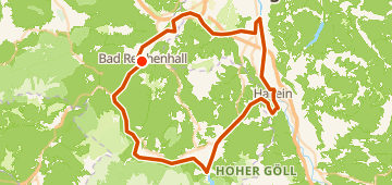
89 km1,168 mLoop3 waypoints
89 km
Distance
1,168 m
Elevation gain
3
Waypoints
Gravel
Surface
With VeloPin Pro your waypoints arrive with the right icons and your notes on a Garmin, Wahoo, COROS or Karoo, instead of as nameless dots.
Just download the route track (.gpx)About this route
This is an 89 km gravel loop starting and ending in Bad Reichenhall, DE. The route features 1160 m of gently rolling climbing and heads out toward Hallein, AT, before returning.
Elevation profile
↑ 1,168 m total climb
Waypoints 3

Near - Diskonttankstelle
Gas station

Bäckerei Niedermayer
Coffee
At a glance
- TerrainRolling — 1,168 m / 89 km
- ShapeLoop
- Best forGravel
- Stops3 waypoints
Surface mix
Asphalt / Paved 56% · 50.3 kmUnpaved / Dirt 3% · 2.6 kmGravel 35% · 30.9 kmUnknown 6% · 5.3 km
More community routes
Vom Murtensee über Fribourg bis Schwarzsee
gravel point-to-point · 64 km · 1,366 m
Vom Murtensee über Fribourg bis Schwarzsee
gravel point-to-point · 65 km · 1,399 m
Gravel Ride To Clee
gravel loop · 102 km · 1,302 m
91km and I'm still thirsty
gravel loop · 91 km · 600 m
Isartal – Blick ins Karwendeltal Runde von Jachenau
gravel loop · 101 km · 1,839 m
Munich's "Where's the Schnitterin?" Loop
gravel loop · 72 km · 338 m